House of Many Colors Olynthus |
The Layout of Olynthus
Olynthus is an ancient city located in Macedonia, an area of northern Greece, about 240 km (150 miles), as the crow flies, north of Athens. The city lies on a fingered peninsula that extends into the north Aegean Sea. The city sprawls across two flat-topped hills, next to the Sandanus River, which empties into the sea 2.5 km (about 1.5 miles) to the south. (The Greeks often chose to locate a city near a seaport for trade reasons, but inland far enough to provide security from invasion.) The surrounding land is gently rolling, but marshland extends to the south, and large hills rise to the north. The region is well-wooded in the hills, and has plenty of pasture land and fertile soil for growing crops. Other ancient towns were within a few kilometers. Olynthus was not a large polis and probably controlled little more than 50 square kilometers of surrounding territory.click on the images to enlarge
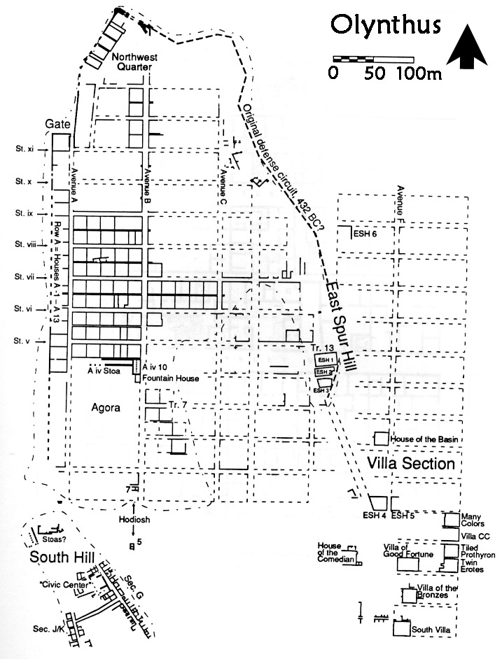
Site plan of Olynthus, showing the largest extent of the city, the major sectors, possible fortification wall, and the House of Many Colors; adapted from N. Cahill 1999:fig. 24; used with permission. |
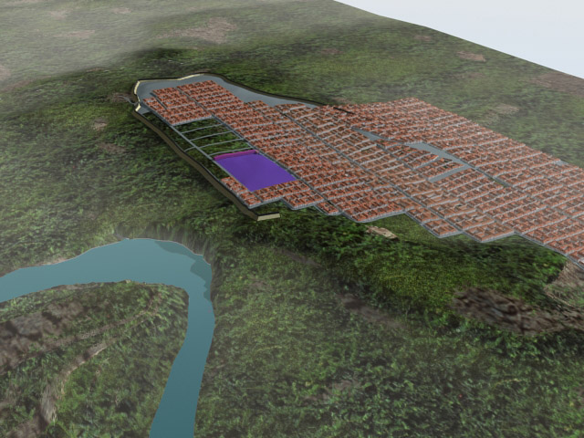
Rendering form the Learning Sites 3D terrain model of the town of Olynthus and surrounding territory; © 2000 Learning Sites, Inc. |
The 3 Main Areas of the Town:
- The South Hill--inhabited briefly in Neolithic times and then re-occupied beginning in the 7th century BCE.
- The North Hill--almost completely built over after 432 BCE with rectangular blocks of houses surrounded by a city wall. It became the heart of the town.
- The Residential Section--located to the east where the land slopes to a plain and built at the same time as the expansion to the North Hill. The excavators dubbed the houses here “villas,” as they are away from the center of town and seem to have belonged to wealthier residents. This is where the House of Many Colors is located.
The public center, or agora of the town is believed to have been in the open space toward the southwest on the North Hill.
Only three public buildings were found here, in the northeast corner of the space that borders Avenue B:
-
a stoa : In Greek architecture, a roofed colonnade, usually open to one side and having rooms off the other side. Stoas were common in ancient Greek cities and building complexes and were used as protected places where people might meet, stroll, or sell their goods
-
a bouleterion: The building in which the boule of an ancient Greek town met. It was usually nearly square in plan and inside had theatre-style seating for the members. It was usually located near the center of the town, most often facing the agora.
-
a fountain house. At the fountain house people came with vessels to carry water to their homes. The fountain was supplied by an underground terracotta pipe that has been traced running north across town, and is believed to tap a fresh mountain source 12 km (about 7.5 miles) away!
Shops tend to be concentrated in the west part of the North Hill. By far the greatest number is along the wide Avenue B, which apparently was intended to be a commercial extension of the agora proper. We can imagine a lively atmosphere here, with residents, craftspeople, vendors, and buyers mingling freely. By contrast, the eastern suburb of the North Hill -- the Villa Section -- has no evidence of shops and must have been a much quieter, residential part of the city.
Sections of the city fortification wall were located along the west edge of the North Hill, with a main gate at the north end of Avenue A. The original wall probably continued along the east of the hill. The Villa Section thus lies beyond the city's walls. Three separate cemeteries were found outside the city.
Some important building types have curiously not been located in Olynthus. One is a theatre, so important in many Greek cities as a place for entertainment and general assembly.
More surprising is the apparent lack of temples or shrines, which are so closely connected with town life elsewhere. Temples were often built on the most prominent spot in or around a town; at Olynthus, the highest ground on North Hill is where the agora sits, but no sanctuaries were found here. The image of Apollo appears on Olynthian coins, so he was probably the patron deity of the city, and an official document written on stone, found less than a mile west of the city, refers to the "temple of Artemis at Olynthus." Artemis was Apollo's sister, so it is not surprising to find she was worshipped. Not all of the site has been excavated, however, and it is possible that temple remains are as yet undiscovered and that shrines have either not been found or are not recognizable in the remains.
History of Olynthus
A small town had existed on the South Hill since the 7th century BCE. As events were heating up to the Peloponnesian War (431-404 BCE) in southern Greece, Olynthus and a number of other towns in Macedonia were controlled by the Chalcidian people. The Chalcidians were allied with enemies of Athens, the most powerful of the Greek city-states. In 432 BCE the Macedonian King Perdiccas, also an enemy of Athens, persuaded the Chalcidians to form a league and strengthen their position by moving together into a single town.Writing at this time, Thucydides (1.58) tells us:
"Perdiccas at the same time persuaded the Chalcidians to abandon and pull down their cities on the sea-coast and settle inland at Olynthus, making there a single strong city. . . . And so they proceeded to dismantle their cities, move inland, and prepare for war."
At this time, or shortly thereafter, the new portion of Olynthus was planned and built on the North Hill to accommodate this influx of peoples. The new portion, which nearly doubled the city's size, was laid out in the checkerboard form that is called the Hippodamian plan. It thus is an early example of the orderly town planning that would become more common in Hellenistic and Roman times.
Eventually, 80 years later, the Chalcidians made peace with Athens. However, Philip was now king of Macedon and was still at war with Athens. The Chalcidian turnabout angered him, but an even greater affront was committed three years later when Olynthus sheltered Philip's half-brothers who wanted to take the Macedonian throne from him. Philip demanded the surrender of his brothers, and when he was refused he marched on the Chalcidians. Olynthus appealed for help to Athens, which sent 2000 men in ships. But they were too late. In August of 348 BCE Philip attacked the Olynthians in their city, and we are told that he:
"confined them to the defense of their walls; then in the continuous assaults that he made he lost many of his men in encounters at the walls; but finally bribed the chief officials of the Olynthians, Euthycrates and Lasthenes, and captured Olynthus through their treachery. After plundering it and enslaving the inhabitants he sold both men and property as booty."
(Diodorus Siculus*, 16.53)
The town, looted and damaged, was largely abandoned to the natural forces that eventually buried it. The expanded city probably had a population of at least 10,000 and was less than a century old when it was destroyed by Philip. This short history makes the site of great use to archaeologists, as it does not have the alterations, additions, and rebuilding that are typical of sites inhabited for centuries. The foundations of over 100 houses were excavated here, giving us a unique and detailed glimpse of residential life in ancient Greece.
Reference
Page Created: January 3, 2004
Page Updated: January 14, 2012
URL:
Page Author: The Institute for the Visualization of History